HDOT implements features to help drivers navigate traffic and improve infrastructure
Posted on Aug 6, 2018 in Main, NewsChanges implemented to help drivers Beat the School Jam
HONOLULU – The Hawaii Department of Transportation (HDOT) Highways Division is reminding the traveling public that more than 45,000 public, private, and college students return to school this month, which historically has increased travel times during peak morning and evening hours.
In an effort to help Beat the School Jam, HDOT will suspend construction-related road closures on major state highways from Aug. 20 – 24 between the hours of 6 a.m. to 8 p.m. to alleviate congestion and help people transition into the new school year. During the daytime construction break, emergency closures, nighttime construction, and roadwork that does not involve lane closures may still be scheduled.
HDOT reminds people to plan ahead, adjust commute times, make sure your vehicle is in good working order, consider carpooling or public transportation, and watch out for children walking or biking to school. Most importantly, drive smart and safe.
“We have made significant improvements to Hawaii’s transportation infrastructure in the last few years. We will continue working to improve traffic and to help drivers and pedestrians safety navigate through our busy roadways,” said Gov. David Y. Ige.
HDOT has implemented time saving and safety measures to help people travel more efficiently. Some of the improvements include:
GoAkamai traveler information expansion over the Koolau routes
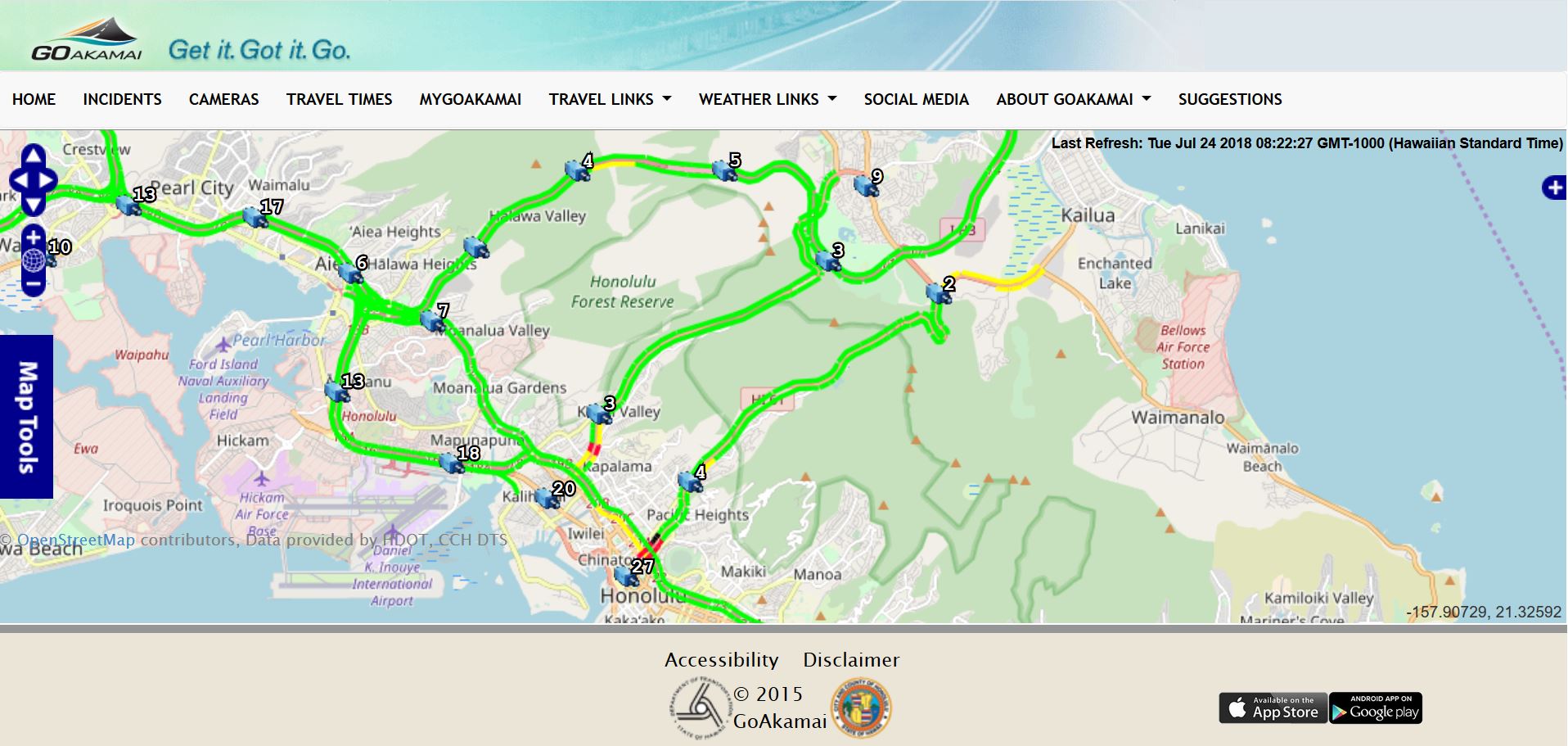
Beginning Aug. 6, the up-to-the-minute traffic conditions and travel time information on the GoAkamai website and mobile app has expanded to cover the Trans Koolau routes of the Pali Highway, Likelike Highway, and H-3 Freeway. The information lists traffic congestion, accidents, and incidents on the three roadways to help drivers determine which route is the clearest. The H-3 Freeway coverage extends from the Halawa Interchange to the Marine Corps Base Hawaii. The Likelike Highway congestion map includes the area between the H-1 Freeway and Kahekili Highway in Kaneohe. The coverage area on the Pali Highway extends from the H-1 Freeway to Kalanianaole Highway at Castle Medical Center (beyond the Castle Junction intersection). To view a photo of the Koolau route coverage areas click here.
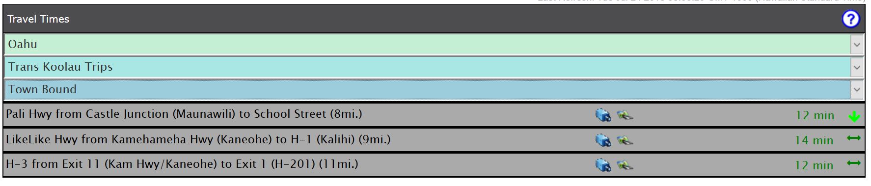
The site also features estimated travel times for each of the three routes. To view a screen shot example of the Trans Koolau travel times click here. The Pali Highway accommodates an average of 54,000 vehicles a day, the H-3 Freeway 49,000 vehicles and the Likelike Highway 35,000 vehicles a day. Travel information is already displayed in GoAkamai for the H-1, H-2, and Moanalua Freeways. Whether traveling a short distance or across the island, people are encouraged to check conditions before every trip to plan the best route.
Travel time message boards
The travel time message boards launched July 16 to give people estimated travel times on the H-201 Moanalua Freeway and the H-1 Freeway Airport Viaduct. The message boards inform drivers of the estimated travel time for each route to help them decide which route is better for their weekday commute, without having to look at their phones. One sign is activated in the morning hours from 5 a.m. to 9 a.m. on the Kaamilo Street overpass to benefit eastbound drivers. Another sign is activated in the afternoon hours between 3 p.m. to 7 p.m. on the Liliha Street overpass to help westbound drivers.
Camera views of routes in the East Rift Zone
Hawaii Island motorists can see routes in the east rift zone on our page https://ops.punatraffic.com to help them make decisions and get information about lifelines like Highway 11 and Highway 130. Work to add camera views and modernize state-owned traffic signals continues on all islands.
Piikoi onramp closure
An HDOT study found closing the Piikoi Street onramp to the H-1 Freeway eastbound on weekdays from 3 p.m. to 6:30 p.m. will save drivers on the freeway six minutes when traveling through the area. The study showed there was minimal impacts to surface streets. The afternoon peak hour closure began July 30. HDOT will monitor conditions over a six-month period and determine if the program will be modified.
New lane on Moanalua Freeway westbound
A new 24/7 lane was built and opened on the H-201 Moanalua Freeway westbound beginning in Red Hill through the H-1 Freeway westbound onramp. The third lane opened in April 2018 and added immediate benefits to drivers.
H-1 Freeway pavement rehabilitation
HDOT is replacing portions of the H-1 Freeway from Waimalu to Halawa that had been covered with bumpy asphalt with precast concrete panels for a smooth driving surface. This portion of the project is scheduled to be finished in September 2018, weather permitting. Phase 2 improvements include widening of the eastbound H-1 Freeway shoulder between the Waimalu Viaduct and the Aiea offramp, highway lighting replacements, drainage systems upgrade, and safety upgrades to the shoulder lane.
Highway infrastructure improvements
Pavement, intersection, and infrastructure improvements are currently underway on Farrington, Pali, and Kalanianaole Highways. The Farrington Highway project added left turn lanes in Nanakuli and is repaving the roadway, installing intersection improvements, and modernizing traffic signals. A contraflow was also added to help westbound commute traffic.
The Pali Highway project includes repaving the roadway, adding new medians, light poles and fixtures, and modifying lanes to accommodate the upcoming sewer improvements by the City and County of Honolulu in Nuuanu.
The Kalanianaole Highway improvements include resurfacing the roadway from the H-1 Freeway to West Hind Drive, guardrail and shoulder improvements, new traffic signals, crosswalk, and bus stop modifications.
Notable neighbor island projects include the Queen Kaahumanu Highway Widening, Phase 2, the Lahaina Bypass, Phase 1B-2, and the resurfacing of Kuhio Highway in the vicinity of Coco Palms.
Statewide Pedestrian Safety Month
August is statewide Pedestrian Safety Month in which HDOT strives to educate the public on good pedestrian practices and driver awareness. The month is organized by HDOT’s Walk Wise Hawaii program and features daily pedestrian safety events. The Walk Wise Hawaii program will offer free pedestrian clip-on lights and reflective safety bands to the public at each of its public events during Pedestrian Safety Month. The public will be able to pick up the Walk Wise Hawaii “Seven Steps to Safety” brochure and its “Drive Wise Hawaii” brochure with safety tips for drivers regarding pedestrian movement. For more information, visit www.hidot.hawaii.gov
HDOT Highways Program Status website
With transparency in mind, HDOT is posting useful information on the Highways Program Status website which allows people to track current highways projects using interactive mapping technology. Available information includes project start date, percentage complete, estimated cost, and completion date. Projects that are anticipated to begin within two years are listed under the future projects section. The program status website has additional information including pavement conditions, traffic counts for specific roadways, bridge information, and ratings and information on fatal crashes throughout the state. The HDOT Highways Project Status Map can be found on hidot.hawaii.gov under the “Current Spotlights” section. A direct link can be found by clicking here.
Freeway Service Patrol (FSP)
The highly successful Freeway Service Patrol (FSP) will continue helping stranded motorists on the freeway system with free emergency roadside service. FSP trucks are on duty every weekday, except holidays, to provide services to keep traffic moving on the H-1, H-2, and H-201 Moanalua Freeways from 5 a.m. to 7 p.m. Stranded motorists may call FSP at 841-HELP (4357). The link to FSP and its services is http://www.fsphawaii.com/
###
