HDOT adds travel time smart boards for Windward Oahu motorists
Posted on Apr 16, 2018 in Highways News, Main, NewsHONOLULU – The Hawaii Department of Transportation (HDOT) is launching a new service for motorists traveling to and from Windward Oahu that will provide current travel times over the Pali Highway beginning Monday, April 16, 2018. The feature is added to help the public with planning during the Pali Highway construction projects and will be available weekdays from 5:30 a.m. – 8:00 p.m.
“We realize the improvement projects on the Pali Highway will impact drivers, and we want to provide information that will help people know what to expect on the highway ahead,” said Governor David Ige. “Drivers will be able to use the information and plan their commutes on the Pali accordingly.”
The solar powered smart boards are located in specific Kailua bound and Honolulu bound locations and will display the travel time to a specific location. The information will help drivers decide if they will remain on the Pali Highway or if they will take an alternate route such as the H-3 Freeway, Likelike Highway or Kalanianaole Highway.
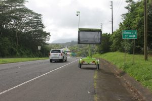
There are four smart message boards serving the Honolulu bound direction. One is located on Kailua Road near the Windward YMCA. Two are located on Kalanianaole Highway near Maunawili Elementary School and Kapaa Quarry Road. The fourth is located on Kamehameha Highway near the Hawaiian Memorial Park Cemetery. An example of a Honolulu bound board is:
Est. time
22 min to
Waokanaka
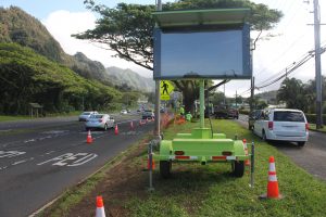
There are two smart message boards serving the Kailua bound direction on the Pali Highway. One is located near the Pacific Height Road exit and another is near Waokanaka Street. An example of a Kailua bound board is:
Est. time
19 min to
Kam. Hwy
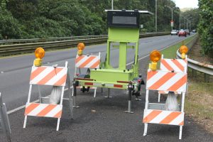
People will notice several smaller pieces of equipment located at various locations along the Pali Highway that collect information which helps determine the estimated travel times. No individual or identifiable vehicle information is collected or stored.
HDOT is working toward adding similar travel time resources on additional roadways including the H-1 Freeway, Moanalua Freeway, H-3 Freeway and Likelike Highway.
The GoAkamai.org website and app are currently available to provide free up to the minute traffic drive times and conditions such as incidents, accidents and construction information on the H-1, H-2, and Moanalua Freeways. The useful website also has access to 200 live traffic cameras located around Oahu. Whether traveling a short distance or across the island, people should plan ahead and check conditions before every trip. Other sources, like Google Maps and Waze, can also help provide accurate conditions on Hawaii’s roadways.
For more information about the Pali Highway projects being conducted by the Hawaii Department of Transportation and the City & County of Honolulu please visit the following sites:

The message board on the Pali Highway near Waokanaka Street is one of the two that will provide travel times for those traveling Kailua bound (the message is not displayed in the photograph). Photo courtesy “HDOT” or “Hawaii Department of Transportation”

The message board on Kamehameha Highway near the Hawaiian Memorial Park Cemetery will provide Honolulu bound travelers with Pali Highway travel times which will help determine if it is better to take the H-3 Freeway (the message is not displayed in the photograph). Photo courtesy “HDOT” or “Hawaii Department of Transportation”

Equipment stations are located at various locations along the Pali Highway to help determine speeds and travel times. Photo courtesy “HDOT” or “Hawaii Department of Transportation”
###
