HDOT launches new travel time messages to help drivers choose the faster route
Posted on Jul 9, 2018 in Highways Posts, Main, NewsHONOLULU – The Hawaii Department of Transportation (HDOT) Highways Division is excited to announce a new trial program designed to provide Oahu commuters with a choice of the faster route between the H-1 Freeway Airport Viaduct or the H-201 Moanalua Freeway. For the initial launch on Monday, July 16, 2018, two Dynamic Message Signs (DMS) will be used and will focus on the morning and afternoon peak travel times.
One sign is located on the H-1 Freeway near the Kaamilo Street overpass for the eastbound morning commute. This sign will be activated from 5 a.m. to 9 a.m. on weekdays. This sign will display the estimated travel time to reach Downtown Honolulu via the Pali Highway Exit 21. A sample message may read:
Pali Hwy Exit 21
Via H1 = 20 min.
Via H201 = 14 min.
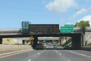
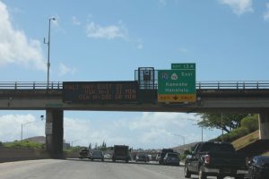
The sign for the westbound direction is located at the Liliha Street overpass for the peak afternoon travel time. This sign will be activated between 3 p.m. to 7 p.m. on weekdays. This sign will display the estimated travel time to reach the Pearl City/Waimalu Exit 10. A sample message may read:
Pearl City Exit 10
Via H1 = 24 min.
Via H201 = 19 min.
“These signs provide motorists with travel times at key decision points so they aren’t tempted to look at their phones while driving. This is another solution that helps get people safely out of traffic and on with their lives,” said Governor David Ige.
The travel time information comes from the same technology used on GoAkamai.org, the helpful site that provides up to the minute traffic conditions and drive times through Oahu.
As always, HDOT encourages drivers to plan ahead by using free resources like the GoAkamai.org website and app. It also has MyGoAkamai, which is a free personalized alerting service to your specific route with freeway alerts such as accidents, construction or other lane closure information. Whether traveling a short distance or across the island, people should check conditions before every trip to plan the best route. Other sources, like Google Maps and Waze, can also help provide accurate conditions on Hawaii’s roadways.
###

